|
|
On the Trail
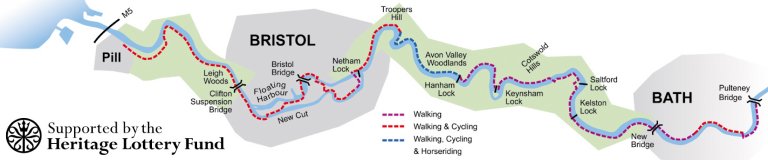
The River Avon Trail passes through the historic harbour village of Pill, the spectacular Avon Gorge, the modern city and ancient port of Bristol, the beautiful countryside where the Avon Valley meets the Cotswold Hills and ends at the famous Pulteney Bridge in the Georgian city of Bath. Although the Trail goes no further, the river continues upstream to its source near Sherston in the Cotswold Hills.
 For walkers
The River Avon Trail is generally straightforward to follow and easy-going as it follows the river and is level along the entire route. The only stiles are between Keynsham and Swineford. The surface and condition of the route is quite variable, particularly in bad weather but future improvements are planned.
  Cyclists
The Trail can be cycled from Pill to Hanham apart from two small sections. It is possible to pick up the Bristol & Bath Railway Path to continue to Bath. Parts of the Trail are also part of National Cycle Network routes 3 and 41.
 Horse riders
The section between Conham and Hanham is a public bridlepath, permitting horse riding. It is hoped that an additional permissive bridlepath will be established to create a circuit as part of other local improvements - watch this space.
Wheelchairs and Pushchairs
Some sections of the Trail are suitable for people using wheelchairs or pushchairs. There are three locations in particular where you can enjoy a trip along the river:
Conham River Park
Disabled parking and toilets available. From here you can head south along the riverside to Beese’s Tea gardens (summer only) via Conham Ferry and admire the surrounding woodlands and fields. The route can be wet and muddy in winter.
The Avon Gorge
There are several car parks at the west end of Cumberland Road in Bristol which provide easy access to the River Avon Trail via the CREATE Centre car park. There are then good quality paths along the river through Brunel Way Picnic Park. You can continue along the edge of Leigh Woods for wonderful views of the Clifton Suspension Bridge and the Avon Gorge. One steep ramp exists at the north-west end of the Park.
Bath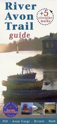
Much of the Trail can be visited as there are a number of ramped access points and the route itself is over one metre wide with good quality surfaces.
Trail Guide For more detailed information about the route, please see the downloadable guide book or phone the Avon Frome Partnership on 0117 922 4325 for your free trail guide.
Ordnance Survey Explorer maps 154 & 155 cover the length of the Trail.
|
|