|
|
 Conham to NewbridgeThe Floating Harbour and the Feeder Canal that extended Bristol harbour's eastern end with a constant water level was opened in 1810. This meant that the area was prime for industrial development. So extensive was the sprawl and the pollution that went with it that the waterway soon became known as 'The Dirty Mile'. The river is still tidal as far as the Netham Weir at the end of the Feeder Canal but is now much cleaner and open space has been created on and around the old industrial remains at Netham, Crew's Hole, Troopers Hill
and Conham.
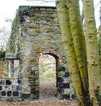
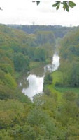 Avon Valley Woodlands At Conham, regenerated woodland, with other varied habitats now make up the Avon Valley Woodland Local Nature Reserve – a haven for wildlife. Trees have reclaimed the quarried rock faces that scarred the steep slopes of the Gorge from Conham to Hanham. The trees also conceal the spoil left by several centuries of copper and brass making activity.
The lock at Hanham was the first to open when the Avon was made navigable in 1727. It is also the first lock of over 100 on the Kennet & Avon Canal that connected the region with London and beyond in the early 1800s.
The Cotswold Edge The northern slopes of the Avon Valley, between Saltford and Bath, form the edge of the Cotswold Hills. The Cotswold scarp has a long history of use for defence purposes. The earthworks from a series of Iron Age hillforts remain and the Battle of Lansdown took place beyond the scarp in 1643.
Roman presence in the area is marked by sites in both the hills and the Avon Valley at Keynsham and Newton St Loe as well as at Bath. Keynsham was much altered in the 1960s. You can find out about this and the area's rich past from Keynsham and Saltford Local History Society.
The typically English river landscape in the Newbridge area has remained relatively untouched for several centuries, despite road and railway building.
|
|